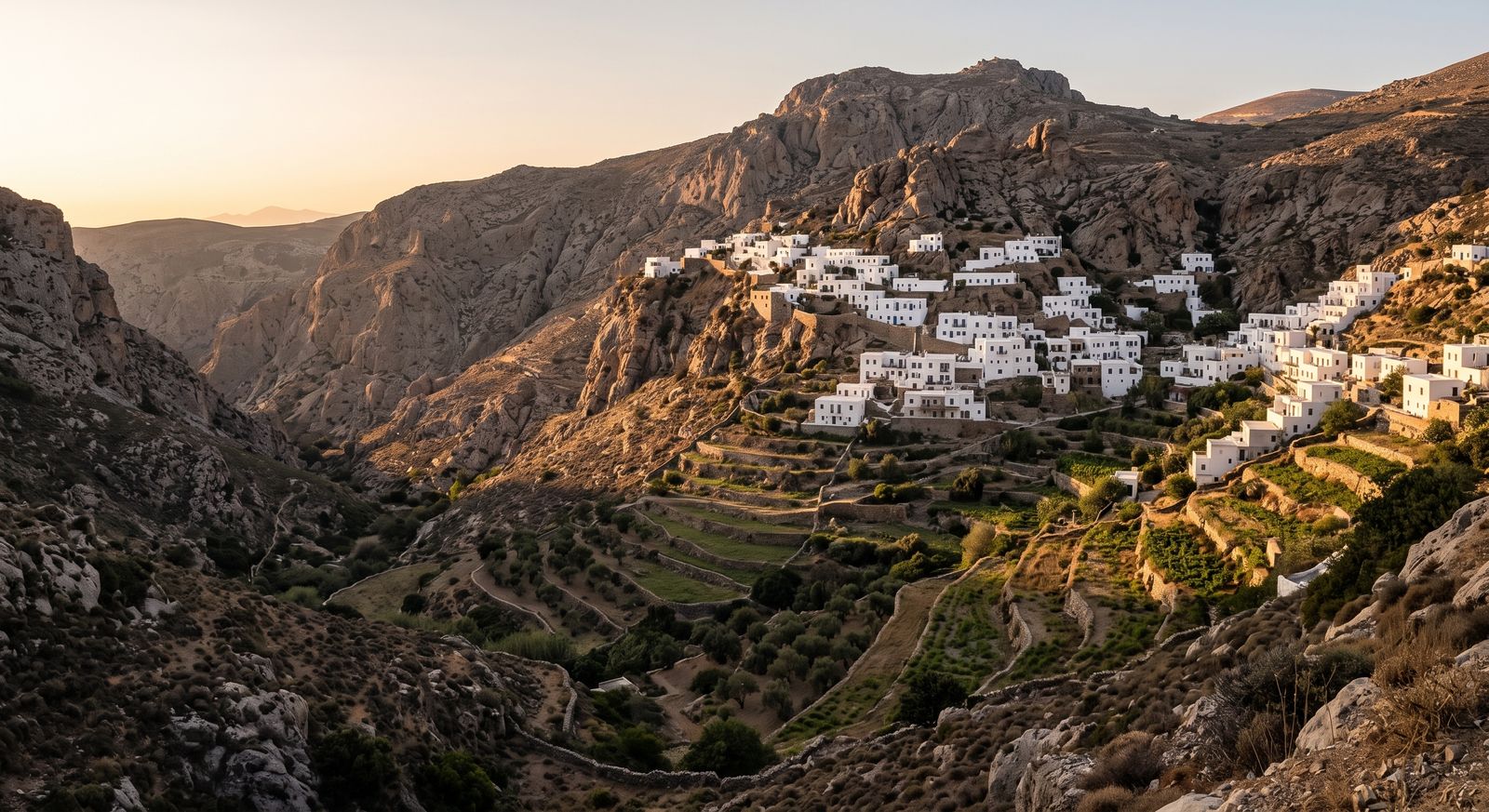
An hour and a half from Granada, on the wrong side of the mountain for tour buses, there is a network of villages connected by footpaths rather than roads.
Most people who visit Granada see the Alhambra, eat somewhere in the Albaicín, and fly home. The Sierra Nevada is visible from the city, and almost nobody crosses it.
On the far side, dropping south towards the coast, the mountain falls away in a series of deep valleys. The villages built into them are whitewashed, flat-roofed, and arranged in a way that makes no sense until you understand they were laid out by people who arrived from North Africa a thousand years ago and built what they knew.
This is the Alpujarra. It is not undiscovered — walkers have been coming for decades and there is a small, long-established foreign community around Órgiva — but it is comprehensively skipped by the coach circuit, and on a weekday in October you can walk between villages for an hour without meeting anyone.
Why the villages look like that
The flat roofs are the giveaway. Nowhere else in this part of Spain builds like this, and the reason is that the Alpujarra was the last part of the Iberian peninsula under Moorish control, and remained substantially Morisco long after Granada fell in 1492.
The roofs are packed with a local clay called launa, which sets hard and sheds water. The covered passageways between houses — tinaos — are rooms built over the street, which is what happens when a village runs out of horizontal space. And the irrigation channels running along the contours, the acequias, are the same system that was cut into these slopes in the tenth century and are in many places still doing their job.
It is worth knowing this before you arrive, because otherwise the villages look merely pretty, and they are actually the most complete surviving example of a landscape that was engineered by hand over centuries.
The three days
Day one: the Poqueira gorge
Three villages sit one above the other in the Poqueira valley — Pampaneira lowest, then Bubión, then Capileira at around 1,400 metres. They are the most visited part of the Alpujarra by a wide margin, which in practice means there are cars and a few shops rather than crowds.
The walk between them is the point. There is a path linking all three that takes a couple of hours at an unhurried pace, climbing through terraces and chestnut. Doing it on foot rather than driving between them changes the place entirely, because the relationship between the villages — which is a relationship of water and gradient — only makes sense when you are moving through it slowly.
Start at the bottom and walk up. The bus runs back down.
Day two: eastward, and higher
Trevélez is one of the highest permanently inhabited villages in Spain, and it is known throughout the country for curing ham — the altitude and the dry air do the work that refrigeration does elsewhere. The village is in three tiers and the upper one is quieter than the lower.
The country between Pitres, Busquístar and Ferreirola is, for walking, the best of the whole region: small villages a few kilometres apart, paths that follow the acequias, and long stretches where the only structures are terrace walls.
Day three: down to Órgiva, or up to the ridge
Órgiva is the market town at the bottom of the valley and is nobody’s idea of picturesque, which is part of its appeal. The Thursday market is the regional one and worth timing a visit around.
The alternative, if the weather is settled and you are properly equipped, is to go the other way. Mainland Spain’s highest peak sits above Capileira, and there are approaches from this side. That is a serious mountain day rather than a village walk — altitude, exposure, and conditions that change quickly — and it should be planned as such rather than added on.
When to go
Spring and autumn, comfortably. April and May bring water down the valleys and everything is green in a way it will not be by July. September and October are dry, warm and clear.
July and August are hot in the lower villages and merely warm in the higher ones, which is why Granadinos come up here in summer. Winter brings snow to the top of the range and the villages can be cold, damp and quiet, which some people prefer.
Getting there and getting around
Granada is the obvious base to arrive at, and the drive over or around the range takes something in the region of an hour and a half depending on which valley you are heading for. Málaga is further but often better served from the UK.
A car makes the region much easier, and a car also makes it tempting to drive between villages rather than walk between them, which is the wrong way to see it. The compromise most people arrive at is to drive to a base and walk from there.
There are buses. They run to a rhythm designed for people who live there rather than for visitors, which means they are useful and infrequent.
THE THING THAT CATCHES PEOPLE OUT
The roads are steep, narrow and full of hairpins, and the distances on a map bear no relation to the time they take. Twenty kilometres between two villages can be an hour of driving.
Plan in hours, not kilometres, and do not arrange to be anywhere at a specific time on the first day.
Staying connected, honestly
Signal in the villages is generally fine — people live here, and the villages are on the network. What is unreliable is everything between them, which is where you will actually be.
The valleys are deep and steep-sided, and a path that contours round a shoulder loses signal for twenty minutes at a time. This matters less than it would in a wilderness, because you are rarely more than an hour from a village, but it matters more than you expect if you are relying on a phone to navigate.
Download the offline map before you leave wherever you are staying. Path junctions here are frequently unmarked, several paths look equally plausible, and the one you want is often the one that appears to be going the wrong way. A map that needs to load is not a map.
A book worth reading first
Gerald Brenan lived in the village of Yegen in the 1920s and wrote about it afterwards. His account of the Alpujarra is a period piece and in places an uncomfortable one, but it remains the reason a good number of English-speaking visitors come here at all, and Yegen is still Yegen.
What not to expect
Restaurants that stay open all afternoon. Anything happening quickly. A single village that contains everything — the interest here is in the relationships between places rather than in any one of them.
And do not expect it to be empty. It is quiet, which is different, and considerably better.
A short list, from the things that catch people out
The offline map, downloaded before you leave the village. Not at the trailhead, where you may already have lost signal.
More water than the distance suggests. The south-facing terraces have almost no shade and the climbs are steeper than the map implies.
Cash. The smaller villages are not reliably set up for cards.
Boots rather than trainers. The paths are stony and the descents are long.
A data connection you can count on when you drop back into a village — for the bus times, the weather, telling someone you are down. A local SIM or a travel eSIM set up before you fly both do the job; the thing to avoid is discovering what your own network charges while standing on a hillside.
Before you go
Three days is about right. It is enough to walk the Poqueira, get across to the eastern villages and still have a day that is not spoken for, which you will want. Two feels rushed, mostly because of the driving. A week is not too many if you intend to walk every day.
A car makes everything easier and also makes it tempting to drive between villages rather than walk between them, which is the wrong way round. Most people settle on driving to a base and walking from there. The buses exist and run to a rhythm built for people who live here.
Go in spring or autumn if you can choose. April and May put water down the valleys and everything is green in a way it will not be by July. September and October are dry and clear. Summer is hot low down and pleasant high up, which is why Granadinos come here in August.
And if you are wondering whether you are fit enough: the village-to-village paths are moderate and well within reach of anyone who walks regularly. The high routes above Capileira are a different proposition entirely and should be planned as mountain days, not added on at the end of a good lunch.